Order Report
⬡ LiDAR Property Analysis

Centuries of history are hiding on your land

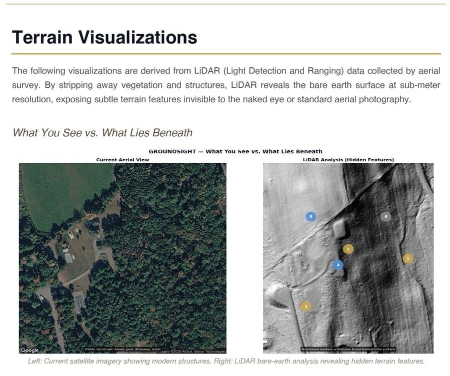
Forgotten roads. Stone walls buried in forest. The foundation of a farmhouse that vanished 200 years ago. LiDAR terrain scanning reveals what your land has been hiding — features invisible to the eye, but preserved in the earth itself.

Discover Your Property's PastStarting at $99 · 24hr delivery
ACTUAL REPORT OUTPUT
What You See vs. What Lies Beneath — satellite view compared to LiDAR analysis revealing 6 hidden features
What you see
What lies beneath
What We Found vs. What We Didn't — honest assessment table

From Colonial homesteads and Revolutionary War fortifications to Civil War earthworks, Oregon Trail wagon ruts, and Industrial-era iron forges — every acre of American land carries the imprint of the people who shaped it. Most of it has never been documented. Until now.

The Reveal

See what's been hiding under the trees

On the left: a normal satellite photo — trees, a house, a yard. On the right: LiDAR strips away all vegetation to expose the bare earth. Suddenly, six historical features appear — stone walls, a sunken road, building foundations — none of them visible from the surface.

Satellite view vs LiDAR bare-earth analysis showing 6 hidden archaeological features

Actual GroundSight output — a property in Columbia County, New York. Left: standard aerial view. Right: LiDAR analysis with 6 numbered findings. The homeowner had no idea any of this existed.

Annotated Discovery Map

Annotated Discovery Map

Numbered markers plotted on LiDAR terrain, color-coded by confidence level — gold for high, blue for medium, gray for low.

Terrain Analysis Suite

Terrain Analysis Suite

Four complementary visualizations reveal features from every angle — hillshade, multi-directional, slope analysis, and color elevation.

Detailed Finding Narratives

Detailed Finding Narratives

Each discovery gets a full investigation: what the LiDAR shows, what it likely is, ranked alternative interpretations, and a field exploration guide.

What You Could Discover

The ground remembers what we've forgotten

LiDAR penetrates tree canopy to map bare earth with centimeter precision — revealing centuries of human activity invisible from the surface.

Stone Walls & Boundaries1700s · COLONIAL ERA

Stone Walls & Boundaries

Hand-stacked from glacial stone by early settlers clearing land. New England alone has an estimated 240,000 miles of walls — most now hidden in forest that was once open pasture.

Forgotten Roads & Trails1600s-1800s · EARLY ROADS

Forgotten Roads & Trails

Sunken lanes worn into the earth by centuries of wagon wheels. Many connected communities that no longer exist — some predate the United States itself. Oregon Trail ruts are still visible 170 years later.

Building Foundations1700s-1900s · HOMESTEADS

Building Foundations

Rectangular depressions where homes, barns, and mills once stood. The geometric precision of human construction — 90-degree corners, uniform depth — is unmistakable in terrain data.

Charcoal Hearths & Forges1800s · INDUSTRIAL ERA

Charcoal Hearths & Forges

Perfectly circular leveled platforms where colliers burned wood to fuel iron furnaces. These features powered America's industrial revolution and are completely invisible at ground level — but unmistakable in LiDAR.

Wells, Dams & Mill RacesALL ERAS · WATER FEATURES

Wells, Dams & Mill Races

Hand-dug wells, spring houses, and channels that powered water mills. One GroundSight customer found a stone-lined well on her property she'd walked past for years — LiDAR spotted it instantly.

Earthworks & Encampments1860s · CIVIL WAR

Earthworks & Encampments

Military trenches, rifle pits, and camp platforms. LiDAR has revealed thousands of previously unknown Civil War sites — many on private property whose owners had no idea.

Layers of American History

What era left its mark on your land?

Every region carries different signatures. Your property might hold one — or several.

PRE-COLONIAL · BEFORE 1600

Indigenous trail networks & habitation

Shell middens, fish weirs, agricultural terraces, and continental trail systems. LiDAR has transformed our understanding of pre-colonial land use.

COLONIAL ERA · 1600-1776

Homesteads, stone walls & early roads

First-generation settlements, cleared fields marked by walls, and roads connecting towns that may no longer exist.

REVOLUTION · 1776-1830

Fortifications, turnpikes & canals

The young nation built roads, canals, and forts. Many were abandoned within decades. The terrain holds their shape.

WESTWARD EXPANSION · 1830-1860

Oregon Trail ruts, mining & railroads

Wagon ruts, mining claims, abandoned rail grades, and ghost town foundations visible in LiDAR 170+ years later.

CIVIL WAR · 1861-1865

Trenches, earthworks & supply lines

Thousands of unknown military sites have been discovered via LiDAR — rifle pits, camp platforms, defensive works never recorded.

INDUSTRIAL ERA · 1865-1940

Charcoal hearths, quarries & mill dams

Iron furnaces consumed forests. Quarries cut stone. Mills dammed streams. The industrial landscape is carved into the terrain.

How It Works

Three steps to discovery

No equipment. No site visit. We analyze government LiDAR data that already exists for your property.

1

Enter Your Address

Tell us where your property is and trace the boundary on a satellite map. Takes about 60 seconds.

2

We Analyze the Terrain

Our proprietary detection engine processes LiDAR data through multiple analysis passes, cross-referencing regional historical patterns.

3

Explore Your Report

Within 24 hours, receive a 15–20 page professional PDF with maps, findings, confidence levels, and a field guide with GPS coordinates.

Pricing

Simple pricing. No subscriptions.

🎯 Introductory pricing — limited time
Standard
Up to 5 acres
$99
One-time · 24hr delivery
Multi-pass terrain detection
5+ terrain visualizations
Annotated discovery map
Ranked interpretations
Field guide with GPS coords
15–20 page branded PDF
Get Standard Report — $99

Secure payment via Stripe · Any US property with LiDAR coverage

Extended
5 – 20 acres
$149
One-time · 24hr delivery
Everything in Standard
Multiple LiDAR tile analysis
Extended historical context
More findings on larger land
Priority processing
20–30 page report
Get Extended Report — $149

Secure payment via Stripe · Any US property with LiDAR coverage

Estate
20+ acres
$199
One-time · 48hr delivery
Everything in Extended
Full parcel multi-tile mosaic
Comprehensive site survey
Exploration zone mapping
Historical topo comparison
30+ page report
Get Estate Report — $199

Secure payment via Stripe · Any US property with LiDAR coverage

🛡️ We verify LiDAR coverage for your property during checkout — before you pay.
What People Are Saying

Real discoveries. Real reactions.

We've lived on this property for 8 years and had no idea there was a colonial-era road running through our woods, or that our stone wall was likely a pre-Revolutionary property boundary. The report found 6 features we'd walked right past. Now every hike on our land feels like an expedition.

K
Kristen M.
Columbia County, NY · 2.4 acres

I was skeptical — how much could lasers really see through trees? Then the report showed a perfect circle in my backyard that turned out to be an old hand-dug well. I walked right to the GPS coordinates, brushed away some leaves, and there it was. Stone-lined, maybe 4 feet across. 150+ years old, completely hidden.

S
Sarah T.
Dutchess County, NY · 3.8 acres
Contact

Questions before you order?

We're happy to help

Not sure if your property has LiDAR coverage? Wondering what we might find in your region? Have a question about a larger parcel or commercial project? Reach out — we typically respond within a few hours.

📍 Based in the Hudson Valley, NY
For properties over 100 acres, commercial parcels, or bulk orders — contact us for custom pricing.
How It Works

Our Detection Methodology

GroundSight uses a multi-stage detection pipeline to analyze your property's terrain. Here's what happens between placing your order and receiving your report.

1

LiDAR Data Acquisition

We source high-resolution LiDAR point cloud data from public datasets covering your property. This data was captured by aerial survey — millions of laser pulses that measured the bare earth beneath tree cover, brush, and overgrowth.

2

Terrain Processing

Raw point clouds are processed into terrain visualizations — hillshade models, slope maps, and elevation renders — that reveal subtle surface features invisible in satellite or aerial photography. These visualizations strip away vegetation and modern clutter to expose the land itself.

3

Feature Detection & Pattern Recognition

GroundSight's proprietary detection engine scans your terrain data through multiple analysis passes, identifying linear features (old roads, stone walls), geometric anomalies (foundations, cellar holes), and landscape-scale patterns (field boundaries, earthworks). Each pass uses a different detection approach to minimize missed features.

4

Historical Cross-Reference

Detected features are cross-referenced against regional historical records, land-use patterns, and known archaeological typologies for your area. A stone wall in Connecticut means something different than one in Virginia — GroundSight accounts for local context.

5

Quality Review & Report Generation

Every report undergoes a final quality review to verify findings, assign confidence levels, and filter false positives. The finished report includes annotated maps, individual feature narratives, historical context, and actionable next steps.

What We Detect Well

  • Stone walls & field boundaries
  • Old roads & cart paths
  • Building foundations & cellar holes
  • Earthworks & berms
  • Terracing & grading patterns
  • Stream channel modifications

Known Limitations

  • ·1-meter LiDAR resolution — small artifacts won't appear
  • ·Surface features only — nothing below ground level
  • ·Detection is probabilistic, not definitive
  • ·Natural features can mimic historical ones
  • ·Modern disturbance may obscure older features
  • ·Coverage varies by state & county

“Think of your report as a detailed treasure map — not a final answer.”

GroundSight identifies features worth investigating. Ground-truthing — walking the property with your report in hand — is where the real discovery begins. We're a starting point for exploration, not a substitute for professional archaeological survey.

Questions

Before you dig in

LiDAR (Light Detection and Ranging) uses aircraft-mounted lasers to map the earth's surface. The key: lasers penetrate through tree canopy and vegetation to reach bare ground, revealing elevation changes as small as 6 inches. These micro-topographic features often correspond to historical activity — a stone wall appears as a linear ridge, a sunken road as a shallow trench, a building foundation as a rectangular depression. Government agencies have flown LiDAR surveys over most of the US, and we access this data for your property.
Approximately 85% of the US has LiDAR coverage through the USGS 3D Elevation Program. Coverage is excellent in the eastern US and most populated areas. We automatically check your property's LiDAR availability during the ordering process, before you pay — so you'll know upfront whether your property is covered.
Every finding includes a confidence rating (high, medium, or low) with ranked interpretations — what we think it most likely is, alternatives, and what it's probably not. We include a "What We Didn't Find" section too. If your property shows minimal historical activity, we say so honestly. Think of it as a detailed treasure map, not a final answer — definitive identification requires boots-on-the-ground verification.
No. Everything is done remotely using publicly available government LiDAR data. No site visit, no equipment, no access needed. Your report includes GPS coordinates so you can explore findings yourself.
Half an acre up to hundreds of acres. Larger wooded properties with less modern disturbance tend to yield the most interesting finds. Suburban lots can reveal foundations and historical features too, but rural and semi-rural properties generally produce the richest results.
Google Earth shows what's visible from above — rooftops, trees, driveways. LiDAR strips away all vegetation to reveal bare ground at much higher precision. A 200-year-old stone wall in dense forest is invisible on Google Earth but stands out clearly in LiDAR. Our analysis also processes the data through multiple detection methods and cross-references findings with regional historical patterns.
Anyone curious about their land's hidden past — homeowners, history buffs, metal detectorists, genealogists, homesteaders, and outdoor explorers. Real estate professionals use reports for distinctive property listings. Land developers order them for pre-construction screening. If you've ever wondered "what was here before?" — this is for you.

Your land has been waiting to be read

Centuries of human activity are written in the terrain beneath your feet. LiDAR can read it. Let GroundSight translate it for you.

Get Your Property Report — Starting at $99